for Sustainable Communities
Characteristics of Form
|
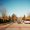
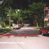
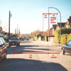
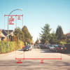
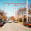
Form: The streets of the Traditional
Pattern are arranged in a grid. This system of neighbourhood "blocks"
bounded by regularly spaced streets running at ninety at a ninety
degree angle to each other results in the characteristic "gridiron"
pattern common to most North American neighbourhoods built
prior to 1940. The most common block form is 180 by 90 metres
(600 by 300 feet), or roughly 5.5 ten long blocks to a kilometre
(10 long blocks to a mile). Commercial services are located within
two blocks of the study site. In neighbourhoods like this one commercial
corridors are usually available within walking distance. Grids
afford many different paths to any particular destination. The arterial
streets can be avoided by bicycles and pedestrians, as necessary.
Although automobiles can travel on interior streets when and if
arterial streets are blocked, residents sometimes object to this
outside traffic. In response to this objection, traffic calming
elements have recently been installed just one block to the east
of the study site. On average there are In this study site
5 metres (16 linear feet) of paved road surface per dwelling unit.
Density: The site, including streets, contains 33 dwelling units per hectare (13.4 dwelling units per acre). The Traditional pattern in this study site would generate 3,300 dwelling units per square kilometre where it to fill one square kilometre for a population of 8,250 people (assuming an average of 2.5 people per dwelling unit). The actual surrounding community of Kitsilano, which includes open spaces, commercial zones, institutional uses, and other non residential uses, has a residential density of 5,660 people per square kilometre. Infrastructure: Of the total site area, 24 percent is paved road, driveway, or sidewalk. For our purposes we have assumed that the lanes remain in their original unpaved condition (note: Vancouver's lanes, traditionally gravel surfaced, are slowly being paved. One of the two lanes on this study site was recently paved). This produces 66 square meters (710 square feet) of pavement per dwelling unit on average. Right of ways (ROW) in this area include the following elements across the right of way profile:
Private front walks often extend through the side yard to the entrance of a dwelling unit located at the rear of the lot. On average, there are 20 square meters (215 square feet) of privately owned paved surface per dwelling unit. Private, paved driveways are atypical of the Traditional Pattern. The storm drain system in the Traditional Pattern is entirely subsurface. Run off is collected by roadside catch basins which feed into a combined storm/sanitary system. Significant water quality problems are associated with this system as treatment plant capacity is exceeded when rain water is added to typical septic flows (thus necessitating the discharge of untreated effluent into receiving waters during storms). The utility infrastructure of the Traditional Pattern follows the
roads and lanes. There are, on average, 5 metres (16 linear
feet) of utility run per dwelling unit.
Coverage and Permeability: On average, 6 percent of each individual lot is paved sidewalk, with a further 43 percent covered by house, storage, and garage structures. Forty nine percent of the total site is permeable surface, which includes lawn, planting beds, and unpaved lanes. Recreation Space: Local recreation for the study site is provided by nearby schools and neighbourhood parks. These provide a mix of field and court sport areas as well as semi-natural areas. There are approximately 14 square meters (151 square feet) per dwelling unit of recreation space located in the immediate neighbourhood, as determined using a 10 minute walking radius. On average it would take 2 minutes to walk to the nearest recreation area, assuming a pace of 1 kilometre per 5 minutes. Virtually 100% of residents are located within a 5 minute walk to the closest recreational space. Commercial and Transportation Nodes: Commercial nodes in the Traditional Pattern are linear in form and typically located along commercial corridors following transit routes. The study area is located within a three minute walk of a major commercial/transit corridor. Not all of the traditional neighbourhoods in Vancouver are quite so convenient to transit and services; however, additional secondary commercial nodes occur at regular intervals throughout the city, placing convenience retail outlets within a five minute walk of almost all residents. Commercial buildings are usually built to the sidewalk edge in this pattern. Most customers who arrive by car use on-street parking. Increasingly parking is provided underground beneath the larger and newer structures that front the main thoroughfare. Public transit is typically provided by busses along commercial streets. For the average resident of the Kitsilano area, it would take 2 minutes to walk to the nearest commercial and transportation node (assuming a pace of 1 kilometre per 10 minutes). Practically 100% of residents are located within a 5 minute walk to the closest commercial and transportation node. Multi-Modal Transportation: In the Traditional Pattern there is no comprehensive alternative system for moving pedestrians and bicycles; however, if so desired all destinations may be reached via internal residential streets, rather than arterial streets. |
|||||||||||||
Community Context
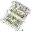
Building Use
Residential Street Section
Type A
Residential Avenue Section
Type A
Residential Avenue Section
Type B
Residential Avenue Section
Type C
Residential Street Section
Type B
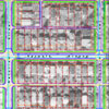
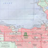
Site Geometry
and Infrastructure