|
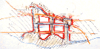
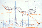
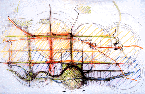
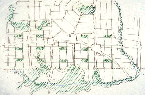
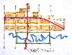
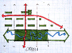
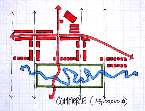
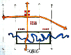
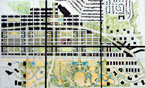
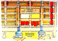
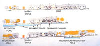
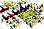
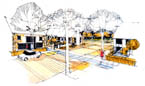
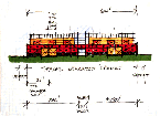
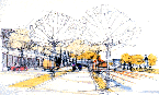
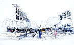
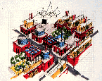
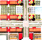
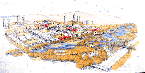
This particular proposal responds to these circumstances not by presenting a literal vision of an anticipated future but, rather, by superimposing a sustainable model onto the existing landscape. An idealized urban pattern rests alongside persisting features of topography and related infrastructure so as to establish a more vivid sense of geographic locale and how it relates to our shared ethic. Such a strategic diagram should serve to remind us that it is the innate and particular conditions our place in nature that lies at the heart of any effort to nurture a sustainable future. Issues of sustainability hinge upon emotional concerns as surely as they do upon engineering and ecological concerns, and this project was started with a deliberate effort to locate some sense of Brentwood Town Centre and its Lower Mainland surroundings. The Still Creek watershed contradicts much of the mythic landscape tradition that is generally associated with this region. Seascapes and extravagant mountain views are only hinted at within this valley of distinct and subtle structure. Observed within this broader context, the Brentwood area is comprised of a series of layered geographical structures rising from the valley bottom. The recognition and reinforcement of this fundamental geographic logic is crucial to any effort to describe a meaningful urban landscape and was a critical point of departure in the groups effort to discover provocative new potential. Since our understanding of the inherent landscape structure informed innumerable decisions, it is worth providing a brief summary of its features. In the valley floor we seized the opportunity to reinstate something of the meandering nature of Still Creek itself while offering open space and recreational amenities that could be extended to existing nearby community facilities. The transportation corridors (railway and highway) that literally gravitated to this location could, in turn, service not only expedient commercial needs, but also make palpable innate qualities of place and circumstance. In particular, an extended wetland habitat could serve as a local feature anticipating the position of Vancouver beyond the next very subtle watershed to the west. The broad extremes of valley are defined by prominent ridges to both north and south, where traditional transportation routes have resulted in intense urban development. The Hastings Street corridor, overlooking the North Shore and the more recent constructions of Metrotown straddling Kingsway to the south, is itself sited on pre-colonial trailways. Within and adjacent to Brentwood a series of significant north-south routes Willingdon, Gilmore, and Holdom Avenues punctuate the continuity of both Still Creek and present-day traffic. These cross-streets inadvertently acknowledge the subtle structure of largely forgotten and often culverted tributaries. The physical pattern of the geography directly informs the structure of the proposed constructed urban landscape. Areas in which the valley pushes north towards the ridgeway sustain secondary transportation links and contain programs of social interchange. Highly visible vertical development occupies the flanking local promontory, and existing public uses (including schools, parks and cemeteries) are encouraged in order to further define the escarpment boundary. The significant outcome of reinforcing these relatively subtle landforms is to more vividly define the middle ground that rests between escarpment and creek. This insistence on topographic legibility serves to dramatically stabilize and, indeed, to dignify the condition of this curious and even awkward terrain, suggesting that these broad understandings of locale might be reinterpreted in local landscapes. Community Structure The primary transportation network of roads, highways, and rail is maintained in layout but elaborated and refined. The design of Lougheed Highway (illustrated in the proposal) confirms the wisdom of choosing that road as the location for the proposed light rail line, the installation of which should be accompanied by a dense and urbane streetscape. The primary transit stop straddles the intersection between Lougheed Highway and Willingdon Avenue, not as a discrete station, as presently proposed, but, as tightly integrated with car and bus traffic as well as pedestrian sidewalks. The concentration of nearby community facilities along with access to major bus routes demonstrates a collective civic commitment to the community. Below the natural escarpment to the north, concentrations of retail and commercial activity offer a local destination while also servicing a dense residential neighbourhood. This neighbourhood reaches its greatest density towards the extreme east and west boundaries of the site. South of Lougheed Highway a continuous fabric of medium-density housing is interrupted by communal garden terraces down the south-facing slope. Tertiary north-south routes contain local neighbourhood shops, and landscaped central medians offer a continuous series of cascades to assist with stormwater management. The concern with stormwater management finds its most specific demonstration in the flat roofs of community service buildings located along the valleys recreation areas. These roofs were specifically designed to enable short-term flood control. Community orchards and allotment gardens within these areas further enhance the sustainable agenda. Drainage proceeds through a sequence of oil traps and sedimentation ponds prior to being dispersed into a series of wet ponds south of the existing railway. The refreshed rainwater is finally released into the renovated course of Still Creek. A variety of recreational facilities is lodged within this general wetland environment and includes a commuter that flanks the railway line to the north. This extensive area of open space connects pedestrian-scaled neighbourhoods, local amenities, and urban trails while continuing to accommodate light industrial and business-park functions. The proposal provides for various forms and densities of housing, suggesting the deployment of historically proven archetypes. In general a favourable solar orientation allows for various passive responses to inform individual building designs. The majority of new units are ground-oriented, largely taking the form of attached terraced housing with individual gardens to the rear. This manner of housing is both economical and readily adaptable to special needs housing. In addition, high-rise point blocks, medium-scaled apartments,
and efficiency apartments above commercial enterprises provide multiple
opportunities to support the diverse needs of contemporary life.
The range of housing type is rounded off with live/work units that
also serve as a natural threshold between local communities and
adjacent commercial, office, and light industrial uses. As in natural
systems, a significant degree of diversity underpins any desire
for social sustainability. Lessons Learned This first sketch of a proposal tests the fundamental hypothesis
that broad geographic structure might profoundly inform the design
and, ultimately, the value of our urban landscapes: a first step
in shifting the conception of sustainability from one characterised
by desire to that of inevitability.
|
||||
|
|
|