SUSTAINABLE URBAN LANDSCAPES
The Brentwood Design Charrette
TEAM ONE  
Back


Detail showing south portion of the plan. Increased density is achieved through the use of row houses on narrow lots. Units front onto narrow residential streets that accommodate local parking. Blocks have rear lanes that function as pedestrian routes (see section Aa below). The grid makes it feasible to access surrounding shops, schools, workplaces, and parks by foot and along the most direct route. A greater diversity and intensity of development frames the edges of the site while still maintaining its connection to the grid. At the south edge, higher-density stacked housing is in close proximity to a school and community centre. A system of drainage channels along streets and laneways conveys surface runoff to a series of sediment traps and retention ponds along the valley bottom (see section Cc).


The 
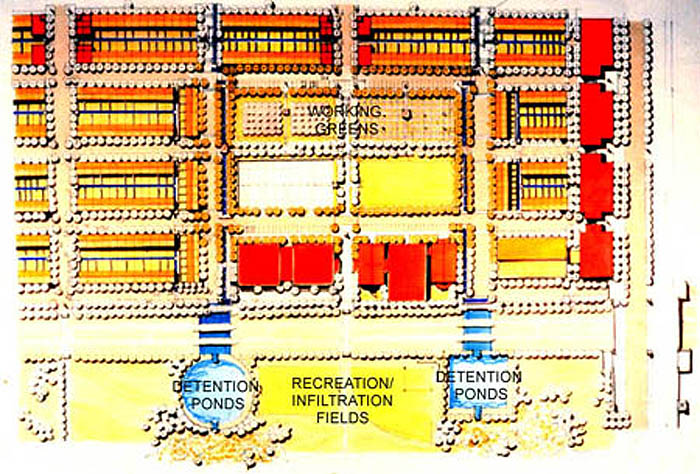
close relationship between community structure, topography, and water management is illustrated in the three sections shown above. Collected first in shallow courses carved into the street, runoff that is not recharged into the soil passes through a series of basins and sediment traps on its way to retention ponds at the edge of the Still Creek corridor. The planting of wetland vegetation (such as bulrushes and cattails) assists in the removal of additional contaminants from runoff. As an extension of the larger aquatic corridor, these areas provide habitat for waterfowl, fish, and other wildlife. Furthermore, they can become an important aesthetic and recreational resource for the community and others. In the bottom section, the central green spaces provide community gathering, working, and recreation spaces while also serving as infiltration basins.