for Sustainable Communities
Characteristics of Form
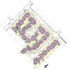
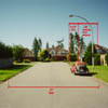
Street Form: The streets of the Status Quo Pattern conform to the dominant arterial, collector, residential, cul-de-sac street hierarchy common to virtually all new communities in North America. This system of ever more exclusive streets results in the characteristic dendritic, or tree-like, form of most new neighbourhoods. The pattern becomes increasingly intricate and fine grained toward the cul-de-sac "branch" tips. In this pattern at least part of virtually every trip will be on an arterial street. In our case study site there is an average of 13 metres (44 linear feet) of paved road surface per dwelling unit.
Density: There are 10 dwelling units per hectare (4.0 dwelling units per acre) on our case study site. This pattern, replicated over a one square kilometre area would provide 1000 dwelling units for a population of 2500 people per square kilometre (assuming an average of 2.5 people per dwelling unit). The actual surrounding community, which includes open spaces, institutional uses, and other non residential uses, has a residential density of 2,020 people per square kilometre.
The first two communities discussed are real neighbourhoods located within the greater Vancouver region. The third is a hypothetical neighbourhood proposed by one of the four design teams during the first Design Charrette for Sustainable Urban Landscapes. We compare and contrast these three neighbourhood patterns in order to answer certain recurring questions about the relative merits of each pattern.
Infrastructure: Twenty five percent of the total case study area is paved road, driveway or sidewalk; that is, on average there are 229-square-meters (2,464 square feet) of pavement per dwelling unit. Right of ways (ROW) in this area include the following elements across the right of way profile:
All dwellings have private, paved driveways and walks. On average, there are 88 square metres (947 square feet) of privately owned paved surface per dwelling unit.
The storm drain system in this pattern is entirely subsurface; however, retention ponds are increasingly required to even flow rates and hold silts. Such retention ponds consume space rendering the pattern less land efficient, and are sometimes treated as nuisance areas requiring fences. The Status Quo Pattern case study area does not include a retention pond on site.
The utility infrastructure follows the roads; thus, the utility system is also arranged in a dendritic "branching" pattern with the same 13 metres (44 linear feet) of utility run per dwelling unit.
Site coverage: On average, 14 percent of each
individual lot is paved driveway and sidewalk with a further 40 percent
of each lot covered by house and storage structure(s). Forty six
percent of the study site is permeable surface, primarily turf lawn
and planting beds.
Recreation Space: Local recreation space for this site is provided on the grounds of a nearby elementary school. This site is typical of other sites throughout the district in that neighbourhood schools and/or neighbourhood parks provide the most convenient recreational sites. These schools and parks are usually dominated by field and court sport areas. Most of these facilities do not contain natural areas. Assuming a 10 minute walking radius (1.0 kilometer), there is an average of 10 square metres (108 square feet) of recreation space per dwelling unit for persons living in this type of area in Surrey. On average it would take 10 minutes to walk to the closest recreation space, assuming a pace of 1/2 kilometre per 5 minutes; however 71% of the total population has greater than a 5 minute walk to the nearest recreation space.
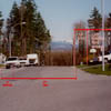
Commercial and Transportation Node: In the Status
Quo Pattern, commercial and public transit nodes are typically clustered
at the intersection of arterial streets. The larger of these nodes usually
include car oriented commercial developments that typically devote more
than half of the site to surface parking. Shop fronts are usually
set back with parking lots fronting on streets. Public transit
is typically provided by busses moving on certain arterials. After
analysing the the larger context we calculate that on average, it would
take 12 minutes to walk to the nearest commercial/transit node (assuming
a pace of 1 kilometre per 10 minutes). Fifty eight percent of the total
population has greater than a 5 minute walk to the nearest commercial/transportation
node.
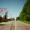
Multi-Modal Transportation: In the Status Quo pattern there is no comprehensive alternative pattern for moving pedestrians and bicycles. Thus, walking and/or biking trips of any length must employ an arterial street for some or most of the trip. This either increases the possibility of accidents or requires additional road width on the arterial. The Status Quo Pattern case study area includes a pedestrian/bicycle connection to link this neighbourhood to the nearest school, partially alleviating this concern.
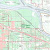
Community Context
Building Use
Major Collector Section
Through Local Section
Limited Local Section
Site Geometry and Infrastructure