|
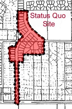
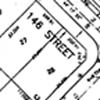
For this section of the study a 4.3 hectare (10.5
acre) proposed development in the South Newton district of Surrey,
British Columbia, was selected as a typical example of development
using the Status Quo Pattern. This project has been approved
for construction and is located between the north-south running
144th- and 148th-Streets and the east-west running 72nd- and 76th-Avenues.
This area will contain only single family homes with one dwelling
unit per lot. We examine the following aspects of this site
for later comparison with the Sustainable Alternative Development:
utility plan, layout plan, grading plan, and street sections.
The Status Quo Development case study site right-of-way is designed
to accommodate all of the services required for urban development:
sanitary and storm sewers, water, electric power, telephone, natural
gas and cable television. These services are buried in linear
corridors either under the pavement or within the boulevard.
Minimum clearances between services are frequently required.
Some services are required to be located beneath a soft surface.
These requirements influence the width of the right-of-way. In the
Status Quo Development case study site there are 13.00 metres (42.60
feet) of utility run per dwelling unit.
Sanitary
In the Status Quo Development case study site sanitary sewers are
constructed under the road pavement. The sanitary and storm
sewers are constructed in a joint trench to reduce the cost of construction.
Storm
The storm drain system is entirely subsurface and is designed to
carry high volumes of water off-site as quickly as possible. An
additional foundation drain system is also present to drain water
primarily from roofs. This system eventually feeds into the
storm sewer. The dual system is beneficial to developers who
incur lower costs; however the city is required to maintain both,
incurring additional costs. The storm and sanitary sewers are
constructed in a joint trench to reduce the cost of construction.
Water
Current city standards require that water lines be buried within
the grass boulevard. In the Status Quo Development case study
site water lines are installed, for the most part under the sidewalk
pavement.
Layout
The average Status Quo Development case study site is 665 square
metres (7389 square feet). Based on subdivision regulations
we expect the average unit to be approximately 214 square metres
(2300 square feet) of interior space on the two main floors.
A full basement is often provided in this type of dwelling but does
not count in the area count since it is not considered habitable
space. This will produce a net floor area ratio (FAR) of 0.32.
Buildings are expected to be set back 6.00 or 8.00 metres (19.70
or 26.20 feet) from the right-of-way with 2.0 metre (6.56 feet)
sideyards. The streets of the Status Quo Development case
study site conform to the dominant arterial, collector, through
local, limited local/cul-de-sac street hierarchy common to virtually
all new communities in North America. This system of ever
more exclusive streets results in the characteristic dendritic,
or treelike, form of most new neighbourhoods. The pattern
becomes increasingly intricate and fine grained towards the limited
local/cul-de-sac "branch" tips. In this pattern at least part
of virtually every trip will be on an arterial street. In
our case study site there are three types of roads: limited collector
with 11.00 metre (36.10 feet) paved roadway within a 20.00 metre
(66.00 feet) right-of-way; through local with 8.50 metre (27.90
feet) paved roadway within a 20.00 metre (66.00 feet) right-of-way;
limited local with 8.00 metre (26.20 feet) paved roadway within
a 16.50 metre (54.10 feet) right-of-way. Overall there are
an average of 13.00 metres (42.60 linear feet) of paved road surface
per dwelling unit within our case study site.
Grading
and Drainage
The Status Quo Development case study site alters the surface
of the site to remove water as quickly as possible. Overland
flow from lots and streets is directed into underground storm sewers
which follow the rights-of-way off-site. The swift removal
of surface water to subsurface systems from paved and roofed areas
eliminates infiltration and ground water recharge from hard surfaces
and reduces infiltration rates from yards.
During large storm events drainage systems can be overtaxed.
Retention ponds are increasingly required to even stream flow rates
and hold silts. Such retention ponds consume space, rendering
the pattern less land efficient, and are often treated as nuisance
areas requiring fences. They are an effective means of slowing
rates of discharge into streams. They are less effective at
sequestering pollutants and do very little to recharge ground water.
In our case study site a temporary retention pond is proposed to
manage silt during construction after which no retention pond is
to be required on site. The City of Surrey is currently working
with Reid Crowther & Partners Ltd. to produce a 'Surrey local
Road Standards Review', in which road width downsizing is being
examined. For the purpose of our study we are examining a
site in which no such new standards have been applied.
The Status Quo Development sections differ primarily in horizontal
dimension. They have the following characteristics in common.
Space: Horizontal Dimensions
A 6.00 or 8.00 metre (19.70 or 26.20 foot) building front setback
which also accommodates a wide concrete driveway. Driveways,
typically in combination with two or three car garages, provide
sufficient parking such that cars are seldom parked on streets.
The 121 square meter (1300 square foot) building footprint (garage
included in this figure) covers 25% of the individual lot on average.
Service: Utility line locations
Precise information on the location of natural gas lines was not
available for this site; however, typically this service is buried
in the boulevard on both sides of the street at a minimum distance
of 0.80 metres (2.60 feet) from the property line.
Precise information on the location of services such as electric
power (Hydro), telephone and cable television is not available for
this site as yet; however, typically these services are buried in
a joint utility trench under the boulevard to reduce visual clutter
on the street. Electric transformers are typically located
above ground in the boulevard with a minimum 2.40 metre (7.90 foot)
clearance from the front of the concrete transformer pad to the
property line.
The sanitary sewer is buried under the roadway centreline.
The storm sewer is buried under the roadway in a shared trench
with the sanitary sewer to reduce costs of construction. Storm
drainage is entirely subsurface.
Water lines are buried in the grass boulevard on one side of the
right-of-way. Lines are located on the opposite side of the
roadway to the electrical utilities at a sufficient distance from
hard surfaces, trees and other services to allow ease of repair.
Hydrants are located in the boulevard on the some side as the water
lines.
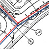
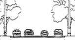
Section
A - : Limited Collector: 146 Street (north arm)
Space: Horizontal Dimensions
A 0.80 metre (2.60 foot) grass boulevard has been provided adjacent
the park.
A 1.50 metre (5.00 foot) sidewalk is provided on one side.
Pedestrians are buffered from automobiles by the 2.00 metre (6.60
foot) gross boulevard which accommodates street trees, light posts,
and hydrants.
The 11.00 metre (36.10 foot) roadway has parking on both sides.
Rollover curbs are included in this width. Cars con move in
both directions without cueing when both parking
tones are occupied,
A 4.50 metre (14.80 foot) grass boulevard accommodates street trees
and light posts.
Service: Utility Line Locations
Water lines are typically buried under the grass boulevard on one
side of the right-of-way. In this section the water line is
buried under the sidewalk pavement.
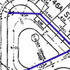
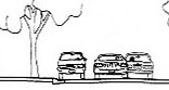
Section B -
Through Local: 146 Street (south arm)
Space: Horizontal
Dimension
A 5.50 metre (18.00 foot) grass boulevard
accommodates street trees and electrical transformers.
The 8.50 metre (27.90 foot) roadway has parking
on both sides. Roll-over curbs are included in this width.
Cars can easily move in both directions but must cue if automobiles
are parked on both sides of the throughway.
A 2.00 metre (6.60 foot) grass boulevard
accommodates street trees and light posts.
A 1.50 metre (5.00 foot) sidewalk is provided
on one side. Pedestrians are buffered from automobiles by
the 2.00 metre (6.60 foot) gross boulevard
with street trees and light posts.
A 4.25 metre (14.00 foot) gross boulevard
accommodates street trees, light posts, hydrants and electrical
transformers
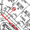
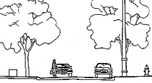
Section
C - Limited Local / Cul-De-Sac: 146A Street
Space: Horizontal Dimensions
The 8.00 metre (26.20 foot) roadway has parking
on one side. Roll-over curbs are included in this width.
Roll-over curbs are preferred by the fire department for ease of
access to homes during emergency. Cars must cue if both parking
lanes are occupied. Pedestrians must walk on the roadway since
no sidewalks are required.
A 2.50 metre (8.20 foot) grass boulevard
accommodates hydrants.
next page
|