table of contents
 
 
SUSTAINABLE URBAN LANDSCAPES
Alternative Development Standards
for Sustainable Communities
CHAPTER THREE  
Sustainable
Alternative
Development
 

A 5.6 hectare (14 acre) portion of the same plan used for the Traditional Pattern with Ecological Underlay case study site (chapter two) was selected as an example of a Sustainable Alternative Development pattern.  As described previously, this as yet undeveloped parcel is located in Surrey on the south side of 64th Avenue, slightly east of the 64th Avenue-King George Highway intersection in Surrey's South Newton district.  The housing mix in this hypothetical neighbourhood is similar to the mix in the Traditional Pattern with an even greater emphasis on secondary suites, row houses, and carriage houses.  We examine the following aspects of the Sustainable Alternative Development proposal: utility plan, layout plan, grading plan, and street sections.

Utilities
As with the Status Quo Development case study site the Sustainable Alternative case study site rights-of-way are designed to accommodate services required for urban development: sanitary and storm sewers, electric power, telephone, natural gas and cable television; however., Modifications have been made which allow for a significant reduction in rights-of -way widths.  Minimum clearances between services are maintained and in some cases eliminated as utilities are completely relocated.  Requirements to locate services beneath a soft surface have been respected.  In the Sustainable Alternative case study site there are 4.2 metres (13.8 feet) of utility run per dwelling unit.

Storm Sewer
The storm drain system in the Sustainable Alternative Development case study site is entirely surficial.  Street-side swales and dished lanes take the place of the typical buried storm sewers.  Decreased flow rates and on-site water storage mean percolation and ground water recharge are maximized.

Sanitary Sewer
As in the Status Quo Development case study site sanitary sewers of the Sustainable Alternative Development case study site are constructed under road pavement.

Water
Water lines in this pattern are buried under the gravel parking lane where they can easily be accessed for repairs.

Gas
Gas lines are buried under the lane as is common in Vancouver's older neighbourhoods

Electric (Hydro)/Telephone/Cable
These utilities are provided aerially from the lane to save space and expense. 

Layout
In the Sustainable Alternative Development case study site the average lot size is 219 square metres (2438 square feet).  Dwelling footprints average 65 square metres (700 square feet) with dwelling unit area ranging from the 56 square metre (600 square foot) habitable lane house to a 378 square metre (4000 square foot) single family residence.  This will produce a net Floor Area Ratio of 1.3. Buildings are set back 3.00 metres (9.80 feet) from the right-of-way with 1.50- to 3.00-metre (5.00- to 9.80-foot) sideyards.  The streets are arranged in a grid configuration that has been modified to allow for the preservation of existing streams.  The study site includes residential streets and residential mews (i.e. streets where drivers must pull onto the shoulder in order to allow other drivers to pass).  Residential streets have a 6.00 metre (19.70 feet) paved roadway within a 15.00 metre (50.00 foot) right-of-way, and residential mews have a 3.50 metre (11.50 foot) paved roadway within an 11.00 metre (36.10 foot) right-of-way.

Grading and Drainage
The Sustainable Alternative Development study site has been graded with a close sensitivity to the existing lay of the land.  Minor grading has been done to the site to establish a natural storm drain system that follows the lines of the pre-existing natural drainage system.  Storm water from streets and lots flows into dished lanes and street-side swales which in turn feed into retention swales that frame the community gardens.  The gardens are designed to completely fill if necessary.  In the vast majority of cases rain water returns to the ground water table under the neighbourhood and flows very slowly underground through the soil to the stream channel before reaching the retention swale.  This slow filtration process helps to cleanse the water and supply ground water to the stream during summer months.  Riparian strips bounding the streams act as bikeways, walkways, and natural recreation areas.  Additional best management practices, such as infiltration trenches under roadside swales could be built into road profiles as necessary to meet even the most ambitious hydrological goal.

Street Sections

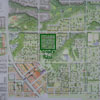
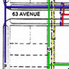
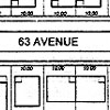
Section A- Residential Street: 63 Avenue

Space: Horizontal Dimensions

The roadway, narrowed to 6.00 metres (19.70 feet) from the typical 8.50 metre (27.90 foot) standard, requires much less pavement than the Status Quo Development street; yet, it allows two lanes of traffic to move since parking is accommodated on gravel shoulders.  Flush concrete curbs, included in the road dimension, replace the standard curb & gutter system and maintain the integrity of the asphalt paved edge.

A 3.00 metre (9.80 foot) strip accommodates a 2.00 metre gavel parking shoulder and a 1.40 metre grass boulevard/swale for street trees, hydrants and light posts.

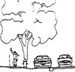
The 1.50 metre sidewalk (5.00 foot) provides space for two people walking abreast.  It is buffered from the street by parked cars and street trees.  The sidewalk is located adjacent to the property line; the grass boulevard typically separating walks from yards is eliminated.

A 3.00 metre (9.80 feet) building front setback creates a small front yard which, in combination with the front porch, helps to increase the level of interaction between residents and the public realm.

The narrow but tall 8.00 meter (26.20 foot) building footprint helps to increase the permeability of the site while also providing comfortable outdoor living space for residents.  Buildings are designed such that there are four habitable floors.

A 9.00 metre (29.50 feet) back yard ensures adequate building to building distance between the principal dwelling and the lane house in case of fire, and provides a generous rear yard.

At the rear of the lot is a 7.50 metre (24.60 feet) habitable lane house.  This structure provides an additional dwelling unit on the lot while providing enclosed parking for both dwelling units. In this way site efficiency is greatly increased.

Ample on-street parking reduces the need for in-lane parking.  The back lane is reduced to a 5.00 metre (16.40 foot) right-of-way from the typical 6.00 metres (19.70 feet).
Automobiles must 'pull -over' to allow oncoming traffic to pass.  The lane profile is dished allowing it to act as a water conduit.

Service: Utility Line Locations

The sanitary sewer is buried under the roadway centreline, as is typical.

Water lines are buried in the road right-of-way, as is typical. Lines are located under the gravel parking shoulder at a sufficient distance from hard surfaces, trees and other
services to allow ease of repair.

Gas lines are buried in the lane which allows for a narrower road right-of-way.

Storm water drainage is collected in graded lanes and roadside swales.  These shallow swales replace the typical buried storm drain system.  Water drains from the site to retention swales which encircle community gardens. Here excess runoff is held to gradually percolate back into  the soil and for slow release
directly into the stream; however, for the average storm event, water is absorbed by the street side swales well before reaching the retention swale.

Other utilities including electrical, telephone and cable are held aloft on poles in the alley.  This location allows for a narrower road right-of-way and greatly increases ease of repair while substantially reducing cost of installation. Locating joint utility poles in the alley removes visual clutter from the street.

Section B- Residential Mews: Elm Street

Space: Horizontal Dimensions
The mews paved way is narrower still; down to 3.50 metres (11.50 feet) from the typical 8.00 metre (26.20 foot) standard.  These streets are primarily intended for limited use by locals, particularly for parking; however, the narrow roadway does allow two way traffic in a 'cueing' situation wherein one car must pull into the parking lane to let another pass by.  Flush concrete curbs, included in the road dimension, replace the standard curb & gutter system and maintain the integrity of the paved edge.

A 2.25 metre (7.40 foot) strip accommodates a 2.00 metre (16.40 foot) gravel parking shoulder and a 0.65 metre (2.13 foot) grass boulevard/swale for street trees, hydrants, light posts, and roadside swales.

The l.50 metre  (5.00 foot) sidewalk provides space for two people walking abreast. It is buffered from the street by parked cars and street trees.  The sidewalk is located adjacent the property line; the grass boulevard typically buffering the two is eliminated.

A 1.50 metre (5.00 foot) side-yard increases land use efficiency and puts 'eyes on the street' for safety and community.

The narrow but tall 9.00 meter (29.50 foot) building dimension helps to increase the permeability of the site while also providing comfortable outdoor living space for residents.

A 3.00 metre (9.80 foot) side-yard provides access from the front street to the back yard and is large enough to be a useful garden space.

Service: Utility Line Locations

Note: Residential mews are cross streets which in this plan do not carry any utilities.  This section depicts what might occur should the residential mews be required to carry utilities.  Sanitary sewer, water lines, and storm water drainage would be provided in the right-of-way as they are in the Residential streets.  Natural gas, telephone, cable television, and electric (Hydro) would be provided by way of the lane as is done in the Residential streets.

Parking provision is a major function of Residential Mews, without which our 2.5 off-site parking spaces per dwelling unit requirement could not be achieved.

Building Plans

Provincial and national policy suggests that social equity must be a vital attribute of any vision for a sustainable future.  Consequently every effort should be made to provide decent housing for as many different family types and income levels in the community as possible.  Traditional communities often accommodated various lifestyles and income groups quite naturally because the houses on a street were all different sizes and residential lots often contained different numbers of dwelling units on them.  In our case study example we try to do the same; we show a mix of houses on the same street and between one and three dwelling units on the various residential lots.  We have varied the width of the lots on each street to accommodate these many building types. Lot widths range from a low of 21' to a high of 39'.  Each lot width, lends itself to a very different type of structure: row houses with party walls for the narrower lots, duplexes with square plans on the wider lots.


Streetscape
A schematic drawing of the streetscape looking east down the proposed Beech Avenue shows how the community might feel if it were actually built.  The wide variety of dwelling types and sizes on this street is, to some extent, masked by the similarity in massing, height and detail of all the structures.  Common touches such as protected porches, front yard fences and hedges, similar roof pitches and overhangs, and similar window details all contribute to a powerful sense of unity - a hallmark of most desirable communities.  Yet the unity here is not one of exclusion.  It is not a unity of single incomes or homogenous lifestyles.  It is a unity that includes many different kinds of people in a cohesive community that is worth sustaining.

next page


Context:


Utilities:


Layout:


Grading and Drainage:


Section A


Section B:


Duplex & Townhose Plans


Single Family Home Plans


Zero Lot-Line Duplex
with Lane House 


Streetscape Perspective

Contact Us
JTC HOME