Introduction
An Integrated Approach to Design
Importance as a Model
Next Steps
Project Partners
|
|
|
INTRODUCTION
Located 30
km south of Vancouver, Surrey is one of Canada's fastest growing
municipalities. As a member of the Greater Vancouver Regional
District, Surrey is dedicated to planning for and managing
its growth effectively through the four broad strategies outlined
in the Region's "Livable Region Strategic Plan":
| *
protecting the green zone (a long-term boundary for urban
growth intended to protect the region's natural assets
such as parks and watersheds) |
| *
building complete, sustainable communities |
| *
achieving a compact metropolitan region |
| *
increasing transportation choices |
With
this approach to managed growth and development in mind, in
January 1999, Surrey's Department of Planning and Development
entered into a partnership agreement with UBC's James
Taylor Chair, the Pacific Resources Centre, and a multi-constituent
advisory committee involving various levels of government
to create the Headwaters Project. The Headwaters Project is
a real-life demonstration of sustainable development principles
and performance standards in a community neighbourhood environment.
The Project is co-administered by the James Taylor Chair,
whose role is information management and project facilitation.
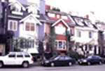
Sustainable Planning Principles
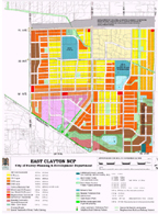
The first phase of the Headwaters Project is the East Clayton
Neighbourhood Concept Plan. The Neighbourhood Concept Plan
is unique in that it is guided by and applies 7 sustainable
planning principles:
1. Increase density and conserve energy
by designing compact walkable neighbourhoods. This will encourage
pedestrian activities where basic services (e.g., schools,
parks, transit, shops, etc.) are within a five- to six-minute
walk of homes.
2. Provide different dwelling types (a mix of housing types,
including a broad range of densities from single-family homes
to apartment buildings) in the same neighbourhood and even
on the same street.
3. Communities are designed for people; therefore, all dwellings
should present a friendly face to the street in order to promote
social interaction.
4. Ensure that car storage and services are handled at the
rear of dwellings.
5. Provide an interconnected street network, in a grid or
modified grid pattern, to ensure a variety of itineraries
and to disperse traffic congestion; and provide public transit
to connect East Clayton with the surrounding region.
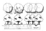
6. Provide narrow streets shaded by rows of trees in order
to save costs and to provide a greener, friendlier environment.
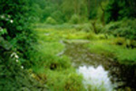
7. Preserve the natural environment and promote natural drainage
systems (in which storm water is held on the surface and permitted
to seep naturally into the ground).
These principles are the philosophical basis for the East
Clayton Neighbourhood Concept Plan, and form the guiding precepts
for the community development.
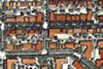
East
Clayton is a Unique Neighbourhood
Once
implemented, the Headwaters Project and the East Clayton Neighbourhood
Concept Plan will represent the first time sustainability
principles have been used in British Columbia as the basis
for developing a new suburban community.
East Clayton will be a place where:
* houses are affordable
* transit is accessible
* commercial services are readily available, and
* natural systems are preserved and enhanced
The Neighbourhood Concept Plan will demonstrate more sustainable
community development standards "on the ground" in a real
community. It will also provide a blueprint for the development
of other sustainable communities. The James Taylor Chair is
recording the Project's evolution. At the completion of the
project, a guide will exist to help other municipalities more
easily develop sustainable communities.
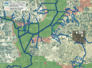
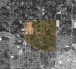
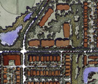
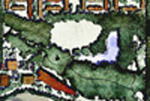
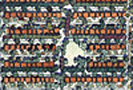
The Site
The East Clayton area includes 250 hectares of land in northeast
Surrey and will eventually provide homes for over 13,000 people.
Situated upland of the region's Agricultural Land Reserve,
the site also drains into three of the area's most significant
water bodies (the Serpentine, the Nicomekle, and the Fraser
Rivers).
|
| |
|
AN
INTEGRATED APPROACH TO DESIGN
Once the decision was taken to develop a sustainable community
in East Clayton, the partners turned their attention to designing
it. In most cases, community development can be described
as a 'disintegrated' process, occurring step by step, with
approval, completion or sign-off of one step required before
the next can begin. A preexisting set of plans that has been
applied in other developments is often, though not always,
used. Each design specialist - representatives of the municipality,
the developer, architect, engineers, planners, inspectors,
contractors, landscape architects, hydrologists and suppliers
- takes a crack at the plans and then passes the drawings
on to the next specialist. Eventually, all the recommendations
are integrated, though sometimes this means merely stapling
them together. The ultimate purchasers are rarely, if ever,
consulted or directly involved in the community development
process. Their input is often limited to design details once
they've agreed to purchase, such as opting for 3 large bedrooms
upstairs rather than 4 small ones, or selecting the colour
of carpets. Because most participants work pretty much in
isolation on their own area of familiarity or expertise, there
is little opportunity to design for efficiency. Instead, the
lack of integrated planning during the design and development
process can result in inefficiencies that not only end up
costing the homeowner more (for example, in the form of higher
energy or water bills), but also degrade the environment.
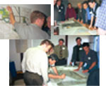
East Clayton - Integrated Planning in Action The integrated
process of a design charrette was the key to the successful
creation of the East Clayton Neighbourhood Concept Plan.
A charrette is a time-intensive, multi-disciplinary, teamwork-oriented
roundtable. In a charrette, everyone who has a stake in a
particular building or community (we should give some examples
- architect, municipal planner, engineers, contractor) gets
together to design it together. This ensures that key synergies
between design elements are captured and that those elements
work together to yield significant energy and resource savings
at the lowest possible cost.
Using this philosophy, the appropriate private, city and regional
institutions, facilitated by design professionals, generated
the East Clayton Land Use Plan during a four day design charrette
held in the spring of 1999. The individuals at the charrette
design table were either vested with sufficient authority
to negotiate new standards "on the fly," or they were delegated
to represent larger constituencies (such as local landowners).
The charrette structure guaranteed that the local landowners'
interests were represented, and it enabled a group of local
individuals to appreciate how the underlying principles and
features of the East Clayton plan came together to form a
highly mixed-use and sustainable community. Carefully developed
and strictly enforced guidelines helped to facilitate the
charrette process.
These simple yet effective guidelines offered
insight, inspiration, and a level playing field to all those
involved in the process. They are:
1. Build capacity for integration through
shared awareness and determination to act jointly.
2. Involve early on (preferably at the beginning) those people,
agencies, and organizations that can influence plan policy
and development standards (including their implementation).
3. Share information equally.
4. Share resources across mandates for mutual gain.
5. Build confidence in the process, in plan policies, and
in alternative development standards. 6. Ensure the direct
involvement of municipal staff.
7. Gain access to the necessary technical expertise.
8. Deal with issues efficiently.
Design professionals served to facilitate, not lead, the charrette
event itself. This point is key, as the Headwaters Project
was envisioned as a replicable model capable of overcoming
the institutional barriers associated with more sustainable
communities. It was recognized that, in order for this to
occur, those individuals typically vested with the authority
to guide development must be provided with new ways to break
the suburban development deadlock. Thus these same individuals
led the charrette while designers acted as facilitators capable
of manifesting their ideas in form.
|
| |
|
WHY
THE EAST CLAYTON SUSTAINABLE COMMUNITY IS IMPORTANT AS A MODEL
- Lighter, Greener, Less Expensive, and More Complete
More than anything else, the
East Clayton Neighbourhood Concept Plan is a "green infrastructure"
plan. East Clayton will be North America's most significant
example of an integrated system of green streets and affordable
sites. Parks, playgrounds, and natural areas are essential
and seamlessly integrated components of the Plan. In the East
Clayton plan nature and city are one, and salmon habitat literally
begins at everyone's front door. East Clayton has narrow streets;
roadways throughout the site use one-third less blacktop than
do status quo suburban sites. Storm water will be managed
to enable natural infiltration to occur, thereby minimizing
runoff and avoiding 80-100% of detrimental downstream consequences.
Yard and street infiltration devices will eliminate nearly
all downstream consequences of development.
What is unique about this project is that no other initiative
anywhere has shown how a combination of efficiencies can decrease
site infrastructure costs while also reducing dependence on
the automobile. The East Clayton Neighbourhood Concept Plan
benefits both the environment and the people who will live
within it. The mixed-use plan means that people can live,
work, and play in the same community throughout their lives
if they choose to. Units will cost 20 - 30% less than a standard
home in the same area, and secondary suites will provide a
mortgage aid for homeowners while providing good housing for
lower income families. Jobs will be located close to homes,
and home-based work opportunities will be provided in the
region's first live/work area located outside of the centre
city. Finally, a "Rapid Bus" will connect all residents to
major employment, shopping, and cultural centers to the east
and west.
EAST CLAYTON WILL BE A COMMUNITY WHERE:
People
may have a car but won't have to use it.
Reduction in vehicle miles traveled per
person per day: 40 %+
Reduction in per capita production of greenhouse gas per capita
attributable to auto use: 40%*
Parents can send their child to the store for a Popsicle
without fear.
Average walking time to the nearest store:
4 minutes
Arterial streets crossed to get there: 0
Parks are a part of each neighbourhood.
Average walking time to the nearest public
park or green space: 2 minutes
Arterial streets crossed to get there: 0
Nature is invited back into the community.
Average walking distance to natural or constructed
stream or wetland: 3 minutes
You
can find a job.
Number of jobs available within the community:
1 per dwelling unit
You can afford to raise a family.
Average reduction in single-family home costs
compared to conventional subdivisions: 20 - 40%
Probable reduction in number of cars per household
over other new neighbourhoods: East Clayton: 1.2 - other new
neighbourhoods: 1.8
Water and the salmon streams are respected and protected.
Reduction in impact on streams when compared
to conventional subdivisions: 90-100 %.
You can take the bus.
Maximum wait for bus service to SkyTrain or
Langley City from Fraser Highway: 7.5 minutes
East Clayton will be the region's first sustainable neighbourhood:
its houses will be affordable; its transit will be accessible;
commercial services and jobs will be available; and, most
important, its natural systems will be preserved and enhanced.
From a regional perspective,
IF EVERY NEW NEIGHBOURHOOD IN THE
LOWER MAINLAND WERE DESIGNED LIKE EAST CLAYTON:
1. There would be 40 % fewer cars on the road.
2. Our region's contribution to global warming from the transportation
sector would be cut by 40%.
3. Our streams would run clean.
4. The salmon would be protected.
5. The expected doubling of our population could be accommodated
without destroying our environment.
6. Public expenditure per resident for maintenance and replacement
of infrastructure would be cut in half.
7. Average wage earners could own their own homes and gardens.
|
| |
|
NEXT
STEPS
The benefits of sustainable community design, described above,
seem dramatic indeed and raise an obvious questions: If it's
this good, why hasn't it been done before now? The answer
is that changing the intricate, entrenched system of regulations
and policies that govern local land-use planning and design
is always difficult. Comprehensive, sustainable improvement
is more difficult still.
A number of challenges still remain in implementing the East
Clayton Neighbourhood Concept Plan.
Our next steps include:
1) to develop detailed design and engineering standards for
the first development site in the community;
2) to demonstrate "green" building and energy systems technologies
on this site;
3) to develop a marketing and communications program for attracting
new homebuyers to this new type of community;
4) to develop an education and monitoring program to assess
the short and long term benefits of the alternative drainage
systems (on stream health, on consumer satisfaction, etc.);
and
5) to develop a site design manual for sustainable communities
that will serve as a tool for other communities, agencies,
developers, etc. to develop more economically efficient, environmentally
sustainable, and complete communities, like East Clayton.
PROJECT
PARTNERS
The East Clayton Neighbourhood Concept Plan is generously
supported by:
City of Surrey
Canada Mortgage and Housing Corporation
Affordability and Choices Today Program (Federation of Canadian
Muncipalities)
Department of Fisheries and Oceans
Environment Canada (Georgia Basin Ecosystem Initiative)
Greater Vancouver Regional District
Ministry of Agriculture
BC Investment Agriculture Foundation
Ministry of Municipal Affairs
Real Estate Foundation of British Columbia
The Project is interested in exploring partnerships
with organizations that promote sustainable communities and
any of the 7 guiding principles. If you would like more information
about the East Clayton sustainable community, or about becoming
a sponsor of this project, please contact:
Patrick Condon
James Taylor Chair in Landscape and Liveable Environments
Landscape Architecture Program
Faculty of Agricultural Sciences
University of British Columbia
2357 Main Mall Vancouver, BC
V6T 1Z4
Tel: (604) 822-9291
patrick.condon@ubc.ca
The
James Taylor Chair in Landscape and Liveable Environments
This
Endowed chair was formed by University of British Columbia
(UBC) in 1994 in direct response to the 1987 United Nations
World Commission on Environment and Development, which concluded
that the solutions to many global environmental problems are
to be found at the local level and, particularly, at the individual
site-development level. Operated through the Landscape Architecture
Program at UBC, the chair is dedicated to advancing both the
scholarship and practice of sustainable design. The chair's
primary goal is to illustrate what our neighbourhoods and
communities could look like if they were designed and built
in conformance with emerging local, provincial, and federal
policies regarding sustainable development.
|
|
+ Data
sauce for this and all other projections: "Tool for Evaluating
Neighbourhood Sustainability", CMHC/SCHL in partnership
with Natural Resources Canada.
*The transportation sector accounts for 41% of greenhouse
gas emission in the Lower Mainland (source: Environmental
Trends in BC, BC Ministry of Environment, Lands, and Parks,
2000).
|
|
|