Lecture by Patrick Condon, UBC James Taylor Chair in Landscape and Liveable Environments.

|
Thank you. It is a great honour to be here in Portland, and so far I have had a great day. I started it, like so many of you, by reading the "Oregonian". There, Fish and Wildlife Service officials were quoted as saying "saving salmon is a local burden" that the municipalities, not the federal government, will have to shoulder. I also read that "the regional planning agency rules could require that a 200-foot buffer be left all along the streams". So far so good; but the following quote really made me sick to my stomach. The article reported that "if Metro's proposed rules are adopted by local government and gain federal approval, all development within the Portland area would be considered exempt from the endangered species act." That is shocking, and dumb. To protect the streams without protecting the watershed is like protecting the forest by saving all the tree trunks while slicing off all the limbs. It does no good to save the trunk of the system and ignore all the leaves and branches that provide its lifeblood. And so for streams: it is the soil in every inch of the watershed that matters, not just the stream channel itself. The 200-foot buffer won't, by itself, save the fish! Come back, Uncle Sam, before it's too late! You see, Uncle Sam, the research suggests that there is only one way to save fish in urban areas: infiltration. And while stream buffers are immensely important, infiltration is downright critical! Natural infiltration rates must be maintained or the fish will die. Without natural infiltration the streams will dry up during dry spells and will be completely torn up when it rains. New research from the Center for Urban Water Resources Management at the University of Washington suggests that, when as little as 10 percent of the watershed is covered with roads and roofs (impervious surfaces), the fish decline. This is very bad news, because our research shows that even low-density suburban development has 40 percent to 50 percent impervious cover. (see Matrix) Now some folks argue that the solution to this problem is to spread things out, to build at much lower densities than we do now so that we won't get above that 10 percent impervious mark. But, unfortunately, this solves one problem by creating four or five others. This approach is another inducement to urban sprawl, and, lord knows, we don't need any more of that. The more we sprawl, the more we pollute the air: we save the streams but poison the atmosphere. More sprawl would require us to build and maintain an even more inefficient infrastructure than we have now (and we already have the least efficient infrastructure on the face of the globe), and, at some point, we would also price average-income citizens out of the housing market. This is simply not acceptable. Obviously, we need a better idea -- and fast! The simple question is this: How can you make a metropolitan area that is livable, affordable, walkable, and doesn't kill fish? And how can those walkable zones provide contact with a preserved and protected nature? |
|
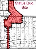
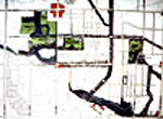
We think that the first step is to think about the site and how it influences the region in an unfamiliar but eminently commonsensical way. At our centre we think of it as follows, and we invite you to do the same: What the cell is to the body, the site is to the region. And just as the health of the body is dependent on the health of the individual cells that make it up, so too is the ecological and economic health of the region dependent on the sites that comprise it. Sites, of course, come in all sizes, and we are interested in them all; but we have come to think of the 400-to-500-acre site as prototypical. It is big enough to be an ecological unit and usually includes a stream or two. A 400-acre site is also big enough to be a community but small enough to walk across in fifteen minutes or so. We chose the design charrette as our method for exploring how site design could affect auto use, stream protection, affordability, and a number of other sustainability issues. Here is the first site we chose: a 400-acre site in the South Newton area of Surrey, British Columbia (see Illustration 1; the results of this particular charrette are available at Surrey Charrette.). We invited top landscape architects and architects from all across North America to participate, and we challenged them with the impossible: we instructed them to meet all of the policy objectives promulgated at various levels of government, many of which conflicted with each other, and to do this all in one place. Why did we set this challenge? Well, British Columbia, like many other Canadian provinces and American states, has many very laudable policies for promoting more sustainable urban landscapes. These policies and laws state that every BC citizen should have access to transit and should have an affordable home. They state that the salmon should be preserved, that the water should be fresh and clean, and that agriculture should be protected (the most important of these laws is the BC Growth Management Strategies Act, 1995). Unfortunately, on the ground, there is very little evidence of the beneficial effect of these laws. Due to the absence of anyplace that even remotely complies with all of these policies, we decided to challenge the charrette designers to draw pictures of what such a place would look like (see Illustration 2). The most impressive feature of this vision for a more sustainable community is evident in the preserved stream system. This system provides the structure for the site, while the recreational areas and the interlaced network of streets leading away from the streams provide the superstructure. This structure and superstructure comprise the "green infrastructure" of the community, and it is this that is at the heart of what I am going to talk about tonight. |
|
There were scores of
individual concepts proposed at our charrettes. We eventually boiled
them down to six simple principles for sustainable communities.
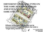
Principle 1: "Locate different dwelling types in the same neighborhood
and even on the same street." Zoning has been the single greatest
instrument for segregating the North American landscape according
to class and income. This must change. And change could be brought
about quite simply by allowing different size parcels on the same
street and different family numbers and arrangements on each parcel.
Thus, for example, a 3,000-square-foot lot might have a 6,000-square-foot
lot on one side and a 4,000-square-foot lot on the other. One or
more of these lots might have a duplex on it or include a secondary
rental suite. This simple device dramatically spreads the income
levels that can be accommodated on a particular street. Principle
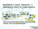
2: Provide buildings that present a friendly face to the street.
Adhering to this principle means never having to see a three-car
garage eating up the whole front of a house. We will come back to
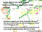
this one later. Principle 3: Transit and shops should be within
a five-minute walking distance. Who can argue with this one? Who
wouldn't like to be able to walk to a shop or transit inside of
five minutes? If it takes longer than five minutes, then you'll
probably drive, right? Most of us would, and the studies are there
to prove it. But in order for a store, even a small convenience
store, to be both viable and within a five-minute walk, it needs
to be surrounded by streets containing about 10 units, or twenty-five
people, per acre. Interestingly, this density seems to be the minimum
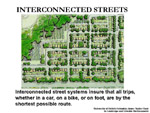
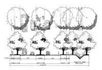
for a viable transit system. Principle 4: Provide an interconnected
street system. Interconnected street systems ensure that every trip
may follow the shortest possible route. It does no good having a
store within a five-minute walk of your home if that walk requires
you to cut through three backyards and jump over five fences. Yet
most of our newer communities are designed to ensure that virtually
all trips are longer than they need to be. Interconnected street
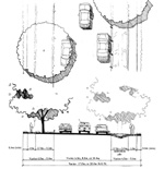
systems, as is shown in this drawing (see Principle 4), can and
should give way to natural systems without compromising the interconnected
tissue of the local street system.
|
|
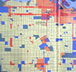
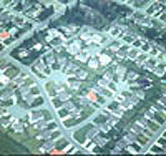
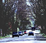
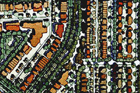
What do neighbourhoods with interconnected streets and ten dwelling units per acre (and above) look like? They look like this (see Illustration 3). On average, a bus goes down this stretch of Broadway (located in Vancouver's West Side) every two minutes. The buses that you see actually pay for themselves (as opposed to suburban buses, which need subsidies of over $10.00 per ride). Interestingly, between 40 percent and 50 percent of the trips in this neighbourhood are conducted by transit, bike, or on foot. Compare this with transit usage levels of 12 percent for the entire Vancouver region (which, while apparently low, are still twice that of Portland, OR, [6 percent]) and with transit usage levels as low as 2 percent in the more suburban areas. The homes that provide all the customers for those shops and buses look like this (see Illustration 4). These houses sit on standard thirty-three-foot-wide by 100-foot-deep lots. This size lot is about one-half to one-eighth the size of typical suburban house lots throughout North America. A tremendous degree of variation can be found in these neighbourhoods. It is not immediately obvious that each of these structures contains two dwelling units. Each of these houses, and, indeed, virtually all of the houses in this desirable area, has a "secondary suite" on the ground floor that is owned and leased by the owners, who almost always live on the upper floors. Rents for these rental units range from $800 to $1,700 per month. Without the income from these units, very few of the resident owners would be able to afford their mortgages. The rental income makes the house affordable while providing good housing in pleasant surroundings for people who are beginning their careers, who don't have sufficient equity to buy a home, or who have other places in which they would like to invest. Thus renters have a place to live that is far more suitable, attractive, and integrated than is the all-too-common and ever-increasing alternative: being segregated by income into vast and featureless garden apartment complexes, townhouse complexes, or low-income projects. This generalized land-use
map explains how this particular Vancouver district can exhibit
such high levels of walking and transit use (see Illustration 5).
The yellow zones indicate residential blocks filled with residential
structures like the ones shown in the previous illustration. The
red areas are smaller commercial districts. Every home in this large
area is within a five-minute walk of at least one commercial district.
These commercial districts also serve as transit pick-up points
for people living within that radius. Remarkably, this more sustainable
land-use pattern emerged without the benefit of our present, "more
sophisticated," land-use controls! But let's take an even more distant
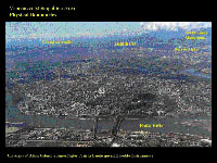
view of this urban landscape. In this aerial view you are looking
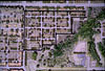
at two-thirds of the homes in our region (see Illustration 6). The
population per square mile is over twice the population per square
mile in the Portland metropolitan region. Most of this area is devoted
to single-family homes and/or single-family homes with a rental
suite. The difference between these single-family homes and single-family
homes in the modern suburb is that the former sit on lots that are
about half the size of those in Portland. You would think that,
with double the population per square mile and no freeways, this
area would be badly congested. It is not. Why? Because residents
have a lot of alternatives in the form of minor streets that run
through this huge interconnected street system. Why has this area
developed at twice the usual density and produced less congestion?
How can this be explained? The answer is that it has fewer freeways
than do most other North American metropolitan areas. As a result
of this, Vancouver avoided the trap into which almost every American
city has fallen. Most American metropolitan areas built enormous
freeways. And the first thing that happened was that the middle
class took them on their way out of town. What they left behind
were hundreds of very nice neighbourhoods that no one really wanted
to live in anymore. Consequently, the property values in these old
neighbourhoods fell off the cliff. This precipitous decline in property
value led to people associating these neighbourhoods with degraded
lifestyles, grim environments, the decay of residential housing
stock, and a host of other social ills (including crime). Now, fortunately
for Portland, its older neighbourhoods were not completely abandoned,
thus enabling it to avoid the nightmarish fate of Detroit and St.
Louis. But, nonetheless, its highways have had a negative effect
-- one that has created the negative legacy with which you are living
today. In Vancouver, without the stimulus of the highway, property
values close to the core of the city increased dramatically in real
terms, tripling at the same time as property values in most older
American neighbourhoods were declining. Today, the selling price
for a thirty-three-foot by 100-foot lot in Vancouver and its surrounding
communities ranges from $250,000 to $600,000, regardless of the
condition of the building that sits on it. The single greatest beneficiaries
of that increase in value were middle-class homeowners whose retirement
is now secure. And their retirement is secure precisely because
the BC government refused to jump on the freeway bandwagon of the
1950s, 1960s, and 1970s. |
|
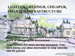
Principle 5: Provide lighter, greener, cheaper, smarter infrastructure.
Lighter, greener, cheaper, smarter infrastructure is the opposite
of the heavy, grey, expensive, and stupid infrastructure we have
now. The gradual increase in the amount of pavement per person,
leading to the fact that the average suburban dweller now has four
times more pavement than does the average urban dweller, has led
to a corresponding increase in the impact, per person, on both the
environment and the public purse. The way to save the environment,
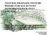
and money, is to pave less, not more. Principle 6: Provide natural
drainage systems. If we want to urbanize an area without destroying
its streams (and every last fish in them), then we must drain new
neighbourhoods in the same way that the original forests were drained:
through infiltration and evaporation. When rain falls on a forest
it adheres to the leaves, branches, and trunks of trees. What doesn't
stay on the trees goes directly into the ground below them. Virtually
none of the water runs over the top of the forest floor to the stream.
In a mature forest, about 70 percent of all the rain that falls
on it returns to the ground. Once in the ground it either seeps
slowly into the deep aquifers far below the surface or into the
shallow water table, where it flows horizontally to the stream bank.
It might take this water a week, or a month, or six months to make
its way to the stream. If you cut off this shallow subsurface flow,
then you cut off the lifeblood of the stream and, consequently,
destroy all the fish. It's just that simple. Thus, in order to protect
the stream and the fish in it as you develop an area, you must find
a way to maintain virtually all of the infiltration naturally occurring
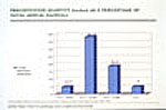
in the watershed. But here in Portland, or up in Vancouver, I get about this far in a lecture and I can usually see the skeptical looks on the faces of some folks in the audience, and I know what they are thinking: "You can't do infiltration in these clay soils! This guy is nuts!" There is a presumption out there that heavy, dense, or what are sometimes erroneously referred to as "clay" soils can't infiltrate storm water. Well, if that were the case, then the forests must have had it all wrong! Of course they infiltrate! They just infiltrate slowly! And the streams located in areas of "heavy" soils are the result of the way these soils infiltrate. Fast, slow: it doesn't matter. Any stream is simply the manifestation of the infiltration performance of the soils in its watershed. So a city, as it builds, must respect these soils and their streams by allowing them to continue to perform together in the way they always have. This is what is required: no more and no less. Unfortunately, we are doing just the opposite. As this picture makes painfully clear, our current compulsion is to get rid of the water as fast as possible and damn the cost (see Illustration 7). With these instructions ringing in their ears, my good friends, the engineers have done their job and done it well. So well, in fact, that they have sucked the lifeblood out of the land. But if we simply change the instructions we give to them, then all this can change for the better. We must instruct them to save the water. This must be part of their job, and they must do it very well. If we simply change the instructions we give to our engineers, then we could eliminate nonpoint source pollution from urbanizing areas, save the fish, and save a ton of money at the same time. In a community such as the one shown, 70 percent to 90 percent
of the total annual rainfall is absorbed on-site in yards, streets,
and lanes (see Illustration 8). The remaining 10 percent to 30 percent
flows overland to the park, where it gets another chance to infiltrate
and/or evapo-transpirate while being held in artificial wetlands
or "dry" retention/infiltration areas. Only after all of this infiltration
has occurred is water allowed back into the streams, and virtually
all of it makes its way to the streams through the cleansing soil,
not through pipes. And establishing this infiltration process is
easy! Portland's rain profile is similar to that of Vancouver. It
rains all the time in the winter, right? But these seemingly constant
winter rains are gentle rains, seldom amounting to more than an
inch a day. In fact, where I live there are only twelve days a year
when rainfall is greater than one inch. Over thirty-seven inches
of the forty-five inches average total rainfall in Vancouver is
attributable to storm events of less than one inch (see Illustration
9). We have plenty of simple ways to build streets capable of infiltrating
this amount of rain, even in heavy soils. We are only talking about
infiltrating about one millimetre per hour, for goodness' sake!
|
|
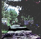
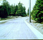
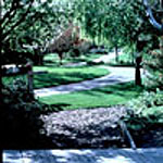
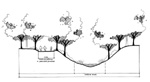
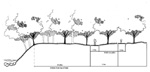
Here is an example of what a lighter, greener, cheaper, smarter street -- one that is capable of infiltrating that amount of rain -- might look like (see Illustration 10). This is an arterial Vancouver street that was built in the 1920s. Residents along this street consistently resist the city's attempts to "upgrade" it, and I am glad they do. This street is never congested, even though it carries over 8,000 cars per day. It has two traffic lanes, two parking lanes on crushed-stone shoulders, street trees, and sidewalks on both sides. This, my friends, is what suburban arterials should look like! Notice that there are no driveways to create dangerous conflicts when residents enter or exit this street. Auto access for these homes is via the back lane (see Illustration 11). This lane has a crushed-stone surface, which is almost as cheap as a dirt surface. It effectively infiltrates water slowly back into the soil and provides a better root zone medium for the urban forest growing in the backyards of these homes. Here, then, is yet another example of easy and effective infiltration. Here is a "rural profile" of yet another arterial road, this one located in a Vancouver Island municipality. Up until recently, arterials in all non-urban areas used this profile. We have only moved away from this standard in the last twenty years. Why? Why do we so love concrete curbs? Can someone explain why it is that, since the first Earth Day, the use of concrete curbs has become a matter of faith and that deviation from this norm is considered heresy? This has got to stop, and this next image proves it. This slide is from the west coast of Vancouver Island (see Illustration 12 ). This is a watering hole for folks escaping from LA or wherever else the landscape has been destroyed. It is, by any standard, a wilderness. But the infrastructure standards presumably mandated by municipal officials in this jurisdiction are no different than the ones applied with such disastrous results in most metropolitan suburban areas -- grey, heavy, stupid, and expensive. What's happening here? Water falling on this street cross-section is trapped between the curbs, and it can't get into the roadside soil. The only way to move it off the street now is to drop it down a grate. From the inlet grate it moves to a pipe, and from that pipe it moves to a bigger pipe, until it is finally discharged into a stream, usually at velocities and volumes many times greater than those to which the stream has adjusted. Recently, retention ponds have been required in many jurisdictions to mitigate the worst of the fast-flush peak that occurs in road systems like this. These ponds help but do nothing at all to protect base flows during dry seasons. This road is sucking the lifeblood out of the stream system and killing fish. This is why we say: "Curbs are evil." To say that curbs are evil is to make a sort of joke, right? How could something so innocuous be so bad? But the truth is, curbs are very bad indeed. Take this design detail and multiply it by the thousands of miles of paved streets in most metropolitan areas, and suddenly you are looking at the cause of an environmental disaster. We need to take a fresh look at this construction detail, and all the other little details of our urban infrastructure, and find a lighter, greener, cheaper, smarter way of providing infiltration. And it's not as though better examples don't exist (see Illustration 13). Amblewood Green in South Surrey, British Columbia, proves it can be done and that the marketplace will accept it. Here, 100 percent of all of the water that falls on the site is absorbed by the soil, right up to the six-inch, 100-year storm event! |
|
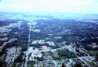
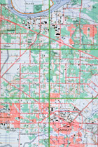
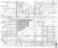
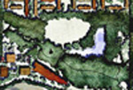
So what would an entire city look like if it were designed to conform
to these six principles? This topographic map depicts 10,000 acres
in the north half of Langley Township, British Columbia (see Illustration
14). It is very similar to your own Beaverton area. It is an agricultural
grid with forty-acre square parcels. Over the years these parcels
have been subdivided, and they are now ripe for urban development.
We took a look at this landscape in order to test our theories on
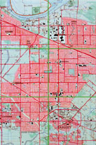
a large scale. First, let me show you an image of the bad old way
-- the way, sadly, that this township will, in all likelihood, develop
(see Illustration 15). This is the "trend" view. Transit usage can
be safely predicted to fall below 5 percent in such a landscape.
The average person will use his or her car twice as much and the
arterials four times as much, as will his or her more urban counterparts.
Given this fact, most commercial activity will gravitate to car-oriented
concentrations on the intersections of main arterials. In short,
we will have auto-oriented sprawl. All natural systems on the site
have been put in pipes. About 100,000 people live here, at an average
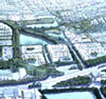
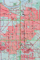
density of three to four units per acre. We have developed an alternative
plan for this area, based on our six principles of sustainable development
(see Illustration 16). On this same 11,000 acres we could supply
homes for 300,000 people at a density of just over ten units per
acre. Eighty percent of these people will live in ground-oriented
homes on parcels averaging 3,000 square feet. The streets in this
plan are interconnected, which means that all trips could be conducted
by the shortest route possible and that there would be many alternative
routes for cars, bikes, and pedestrians. The interconnected street
system would be interrupted by streamways. Some of the streams shown
in these streamways exist right now, but most of them do not. Most
of the new streams shown in this plan are constructed streams: they
are a necessary part of the natural storm drain infrastructure.
These streamways eliminate the need for storm drain interceptors
and suggest an entirely new kind of civil engineer -- one who is
committed to habitat enhancement and water quality protection. Wouldn't
you want to be such an engineer? I sure would! Surprisingly, a walkable,
transit-friendly city such as this one, even with three times the
population of the status quo suburban alternative, need not be badly
congested. Studies show that traffic congestion is more pronounced
in the suburbs, where there are four dwelling units per acre, than
it is in established urban areas whose densities are three times
as high. This alarming disparity in traffic generation is particularly
evident on suburban arterial streets, where congestion creates serious
impediments to regional mobility. |
|
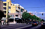
The transit avenues envisioned in our plan would provide the setting for buildings like this one, which is a recent addition to one of the City of Vancouver's numerous pleasant, pedestrian-oriented transit arterials (see Illustration 17). The surrounding economic context for this building is similar to that imagined in the Langley plan. The building is a three- to four-story mixed-use structure -- a type that so-called experts still consider to be non-viable in most North American contexts. But in Vancouver scores of this type of building have been constructed, and the condominium units located within them have rapidly sold out. Vancouver does not have a single example of this type of project failing. The next project we conducted takes us to the other end of the scale telescope (see Illustration 18). From the 10,000-acre site we went back down in scale to a ten-acre site. We wanted to see, in great detail, what the smallest cell in this regional structure was like -- how it functioned, what it cost, and so on. With such a plan we could conduct more accurate comparisons between it and status quo examples, and then we could begin to answer such ever more frequently occurring questions as: Is it cheaper? Can the fire truck get to the house? Where will the water go? What kind of homes could be built and sold in such a neighbourhood? We compared our sustainable alternative plan with the trend, or status quo, plan, complete with 7,000-square-foot lots, wide streets, and cul-de-sacs (see Illustration 19). Then we compared it with this, our alternative proposal (see Illustration 20). Both proposals had homes that were nearly the same size inside at 2,000 to 2,300 square feet. The sustainable alternative has five times as many homes in the same area, located on lots that range from thirty-three by ninety feet for single-family homes to twenty-three by eighty feet for freehold townhouses. Part of this large increase in the number of dwelling units is a function of smaller lots and narrower streets. Another part of this large increase in density is attributable to the inclusion of one rental unit in every second freehold dwelling on the site. The sustainable alternative has much narrower streets, with natural drainage swales in the verges. Car storage and service are provided from the rear via a lane paved with crushed stone. In a typical rain all water that falls on site is absorbed in yards, lanes, and verges. During heavy rains water is conveyed via grass swales to temporary retention and infiltration areas located astride the stream. Based on performance bond information provided by the developer of the status quo subdivision to the City of Surrey, we were able to establish a cost per unit for infrastructure of $23,000. This is the cost of pavements and pipes, all of which, for the most part, would be expended in the street in front of each home. At $4,400, the per unit cost for infrastructure in the sustainable alternative was much lower than that in the status quo plan. This is a saving of close to $20,000 per dwelling unit, all of which, presumably, would be deducted from the purchase price of the dwelling. When land and construction costs are added in, the decrease in per unit costs is even greater. The same size home in the sustainable alternative proposal costs $90,000 less than does the status quo home. |
|
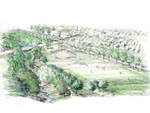
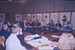
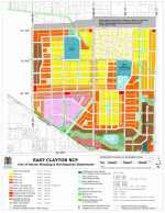
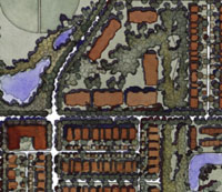
Based on our progress in proving our theories, we were invited to initiate a project to build the first sustainable neighbourhood in our region. In December 1998, the City of Surrey Department of Planning and Development agreed to enter into partnership with our research group, a team of consultants, and a multi-constituent advisory committee (involving various levels of government) in order to produce a model capable of applying sustainable principles and alternative development standards "on the ground" (see Illustration 21). Out of this agreement grew the concept for the Headwaters Project. The "model," and the first and most important part of the Headwaters Project, is the East Clayton Neighbourhood Concept Plan. Public consultation, which took place through the charrette process, was the key to the successful creation of the East Clayton plan. The public and the appropriate private, city, and regional institutions, carefully aided by our staff, succeeded in designing the East Clayton plan during a four-day charrette (see illustration 22). This novel approach to design was necessitated by the need to make myriad digressions from status quo development standards in order to meet the six principles of sustainability. The individuals at the design table were either vested with sufficient authority to negotiate new standards "on the fly," or they were delegated to represent larger constituencies (such as local landowners). The charrette structure guaranteed that the local landowners' interests were represented, and it enabled a group of local individuals to appreciate how the underlying principles and features of the East Clayton plan came together to form a highly mixed-use and sustainable community (see Illustration 23). Design and planning experts served to facilitate not lead the charrette event itself. This point is key, as the Headwaters Project was envisioned as a replicable model capable of overcoming the institutional barriers associated with more sustainable communities. It was recognized that, in order for this to occur, those individuals typically vested with the authority to guide development had to be provided with new ways to break the suburban development deadlock. Thus these individuals led the charrette, while the designers facilitated the former's attempts to put their ideas into concrete form. More than anything else, the East Clayton plan is a "green infrastructure" plan (see Illustration 24). East Clayton will be North America's most significant example of an integrated system of green streets and affordable sites. Parks, playgrounds, and natural areas are essential and seamlessly integrated components of this system. In the East Clayton plan, nature and city are one, and salmon habitat literally begins at everyone's front door. East Clayton has narrow streets; roadways throughout the site use one-third less blacktop than do status quo suburban sites. Storm-water management will enable natural infiltration to occur, thereby minimizing runoff and avoiding detrimental downstream flooding events. Essentially, yard and street infiltration devices will eliminate 100 percent of all downstream consequences of development. Units will cost 20 percent to 30 percent less than a standard home in the same area, and secondary suites will provide a mortgage aid for homeowners. Jobs will be located close to homes, and home-based work opportunities will be provided in one of the region's first live/work areas. Finally, a Rapid Bus (a viable and convenient public transit system connecting the local area to the larger region) will service the community. What is particularly unique about this project is that no other initiative has shown how a combination of efficiencies can dramatically decrease site infrastructure costs while also reducing dependence on the automobile. These dramatic environmental, social, and economic efficiencies have been achieved by ensuring that the East Clayton plan follows the six principles of sustainability that I discussed earlier. The Surrey City Council officially adopted these principles in 1999 in order to guide the development of the Clayton plan. What does this mean in practical terms? It means that, in East Clayton: 1. People can have a car but won't have to use it. Reduction in vehicle miles traveled per person per day: 40 percent. Reduction in per capita production of greenhouse gas per capital attributable to auto use: 40 percent 2. Parents can send their child to the store for a popsicle without fear. Average walking time to the nearest store: four minutes. Number of arterial roads crossed: zero 3. Parks are a part of every neighbourhood. Average walking time to the nearest public park or green space: two minutes. Number of arterial roads crossed: zero 4. Nature is invited back into the community. Average walking distance to natural or constructed stream or wetland: three minutes 5. You can find a job. Number of jobs available within the community: one per dwelling unit 6. You can afford to raise a family. Average reduction in single-family home costs compared to those in conventional subdivisions: 20 percent (40 percent if mortgage-helper rental unit included). Probable reduction in number of cars per household over that in other new neighbourhoods: East Clayton 1.2, other new neighbourhoods 1.8 7. Water and salmon streams are respected and protected. Average reduction in impact on streams when compared to that in conventional subdivisions: 90 percent to 100 percent 8. You can take the bus. Maximum wait for bus service (to SkyTrain or Langley City from Fraser Highway): 7.5 minutes East Clayton will be the region's first sustainable neighbourhood: its houses will be affordable; its transit will be accessible; commercial services and jobs will be available; and, most important, its natural systems will be preserved and enhanced. From a regional perspective, if every new neighbourhood in the Lower Mainland were to be designed like East Clayton, then: (1) there would be 40 percent fewer cars on the road; (2) the air would be 40 percent cleaner; (3) our region's contribution to global warming would be cut by 40 percent; (4) salmon would thrive; (5) the expected doubling of our population could be accommodated without destroying our environment; (6) public expenditure per resident for maintenance and replacement of infrastructure would be cut in half; and (7) average wage earners could own their own homes and gardens. The East Clayton Neighbourhood Concept Plan, the first phase of the Headwaters Project, offers an unprecedented blueprint for sustainable development. It is already influencing the development of "lighter, greener, cheaper, smarter, and complete communities" throughout "Cascadia." Cities from Eugene, Oregon, to Vancouver, British Columbia, are all struggling with the same problem: how can we build at sustainable densities without killing the natural systems that the fish and other creatures (including, in the long run, humans) depend upon? We believe that the Headwaters Project provides a workable model, and we hope that people will take ideas from it and adapt them to suit the needs of their respective areas. |